B.C. weather warning: Almost entire province is on a snowfall or extreme cold alert

Article content
Environment Canada has issued public weather alerts for almost all of British Columbia as a massive arctic system sits over the province.
Article content
On Monday, Environment Canada issued snowfall and wind warnings for the B.C. south coast including Metro Vancouver, the Fraser Valley, Greater Victoria and Vancouver Island.
Article content
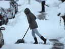
Accumulations of 10 to 15 centimetres are expected through Tuesday afternoon, and as much as 20 cm for the southern half of Vancouver Island and the Southern Gulf Islands.
On top of this there are special weather warnings in effect for 41 of the remaining geographic regions.
These warnings are issued for extreme cold, snowfall, arctic outflow (winds) and winter storm.
Haida Gwaii and the northern tip of Vancouver Island are the only coastal areas with no warnings in place.
Drivers are advised to prepare for changing road conditions and accumulating snow, and the B.C. Ministry of Transportation said anyone whose vehicle is not properly equipped with winter tires should “stay off the road.”
Article content
Snow began falling in Victoria at around 7 p.m. and in Vancouver at around 8 p.m., falling at a rate of one centimetre per hour.
At 8:30 p.m. TransLink began reporting problems, with multiple routes (including the UBC B-Line and CanadaLine), experiencing delays across the region.
The ministry said contractors will be out in full force to manage accumulations and to drop sand for better traction, warning drivers to keep their distance and not try to pass winter maintenance vehicles.
Mainroad contractors are still working around the clock cleaning up after the last snow drop on the weekend, and are preparing to salt, sand or brine roads based on temperatures and conditions. Lane closures may go into effect on the Port Mann and Alex Fraser bridges as needed.
ICBC noted crashes peak in December, with an average of 26,000 incidents, about 2,000 more than B.C.’s monthly average.
The low-pressure system is centred over Washington state, meaning areas south of Vancouver were already starting to see snow fall by late Monday morning.
Strong ouflow winds and the heaviest snow are expected in Victoria, along the Malahat, the Southern Gulf Islands, Lake Cowichan, Port Renfrew and east Vancouver Island from Duncan to Fanny Bay.
Article content
Parts of the Fraser Valley including Hope, Chilliwack and Abbotsford are also under an arctic outflow warning, causing wind chills between –20ºC and –25ºC. Thermostats will read at least five to 10 degrees below seasonal norms in the region through Thursday, though there may be a brief respite due to a Pacific storm moving through on Tuesday that will bring more snow.
Those with pets or outdoor animals are advised to provide proper shelter during the cold snap. Warming centres for those who are vulnerable to the elements are open throughout the area.
Snowfall warnings are also in place along the Coquihalla Highway from Hope to Merritt, Highway 3 from Hope to Princeton along the Allison Pass and the Fraser Canyon including Lytton and the south Okanagan. Those areas are also expected to see 10 to 15 cm, and up to 20 cm on Highway 3.
Snow will ease off late Tuesday morning on Vancouver Island and Tuesday afternoon on the mainland.
As of Monday night there were no significant outages being reported by B.C. Hydro, which is critical given how cold it is and once homes lose power they lose heat.
B.C. Ferries services has reported no delays due to weather.
Road conditions and closures are at drivebc.ca.
-
BC Hydro says holiday storms more frequent in recent years
-

Winter weather tips: How to shovel snow, walk on ice, stay safe in cold
-

Extreme cold means ‘it’s life or death’ for people living on Metro Vancouver streets


Powered by WPeMatico