SURGE POTENTIALS: How much water your neighborhood could see during Hurricane Milton
SURGE POTENTIALS: How much water your neighborhood could see during Hurricane Milton

TAMPA, Fla. (WFLA) — Hurricane Milton is quickly approaching Florida’s Gulf Coast as a major hurricane.
The storm will bring unprecedented storm surge, following Helene’s devastating impacts and flooding just under two weeks ago.
Find your evacuation zone ahead of Hurricane Milton
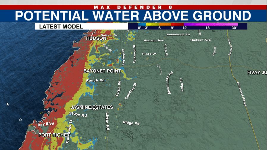
WFLA has compiled neighborhood-by-neighborhood images of how much water is possible from storm surge ahead of the hurricane.
The NHC also has an interactive map that is updated as live hurricane updates are issued.
Pinellas County
-
Clearwater Beach -
St. Pete -
Indian Rocks Beach -
Treasure Island -
Shore Acres -
Dunedin -
Fort Desoto -
Lakewood Estates -
East Lakewood Estates -
Ozona -
Redington Shores -
Safety Harbor


Hillsborough County
-
South Tampa -
Tampa -
Gandy -
Gibsonton -
Ruskin -
Town N’ Country -
Westchase -
Apollo Beach -
Bridgeport


Sarasota County
-
Sarasota -
Laurel -
Terra Ceia -
Vamo -
Venice -
Port Charlotte


Manatee County
-
Bradenton -
Fort Hamer -
Piney Point -
Arcadia


Hernando County
-
Hernando Beach -
High Point -
Homasassa -
New Port Richey -
Weeki Wachee


Pasco County
Citrus County
-
Crystal River -
South Chassahowitzka -
Chassahowitzka -
Northern Citrus


Be prepared with the 2024 Hurricane Guide.
Copyright 2024 Nexstar Media, Inc. All rights reserved. This material may not be published, broadcast, rewritten, or redistributed.
For the latest news, weather, sports, and streaming video, head to WFLA.
Powered by WPeMatico